Urban development today is no longer based on assumptions or rough layouts. Every successful development project begins with accurate, well-prepared geographical map drawings. These drawings form the technical foundation for planning, approvals, design coordination, and construction execution. Without precise geographical mapping, even well-funded projects face delays, legal complications, and costly design revisions. Geographical map drawings provide a clear visual and technical representation of land features, boundaries, elevations, access routes, and surrounding infrastructure. They allow planners, architects, engineers, and authorities to understand the physical characteristics of a site before any design or construction work begins. In rapidly developing regions such as the UAE, accurate mapping is essential to ensure compliance with zoning regulations, infrastructure alignment, and sustainable urban growth. Role of Geographical Maps in Urban Planning Urban planning relies heavily on spatial accuracy. Geographical map drawings help planners assess how land can be utilized efficiently while considering roads, utilities, public spaces, and environmental constraints. These maps support decision-making related to land subdivision, road connectivity, drainage planning, and public service placement. Accurate geographical maps also help avoid conflicts between neighboring plots, reduce land disputes, and ensure that developments align with approved master plans. When planners have access to reliable mapping data, they can design cities that function efficiently and grow sustainably over time. Supporting Regulatory Approvals and Compliance One of the most critical uses of geographical map drawings is in regulatory approval processes. Municipal authorities, planning departments, and infrastructure agencies require precise maps to evaluate development proposals. These drawings must clearly show land boundaries, coordinates, access points, setbacks, and surrounding developments. Inaccurate or incomplete geographical maps often result in application rejections, repeated revisions, and approval delays. Professionally prepared drawings ensure that submissions meet regulatory standards and reduce the risk of non-compliance. This not only saves time but also improves the credibility of the developer or consultant submitting the project. Integration with Engineering and Infrastructure Design Geographical map drawings play a vital role in engineering coordination. Infrastructure systems such as roads, drainage networks, water supply, and electrical services must be designed in alignment with actual site conditions. Accurate maps allow engineers to plan these systems efficiently while minimizing clashes and redesigns. Elevation data, contour lines, and terrain analysis included in mapping drawings help engineers manage water flow, avoid flood risks, and design stable foundations. Without accurate geographical information, engineering designs are based on assumptions that can lead to structural or functional issues during construction. Enhancing Cost Control and Risk Management Errors in early-stage mapping often lead to major cost overruns later in the project lifecycle. Incorrect land measurements, missing site features, or outdated data can result in redesigns, construction delays, and material wastage. Accurate geographical map drawings reduce these risks by providing reliable data from the beginning. When project teams work from precise maps, they can plan construction activities more efficiently, allocate resources correctly, and avoid unexpected site challenges. This improves overall cost control and reduces project uncertainty. Supporting Sustainable and Smart City Development Modern urban development increasingly focuses on sustainability and smart infrastructure. Geographical mapping supports environmental analysis, land-use optimization, and integration of green spaces. It allows planners to assess environmental impact, protect natural features, and design developments that respect ecological balance. Accurate mapping is also essential for smart city initiatives that rely on digital data integration. Geographical maps serve as the base layer for GIS systems, smart infrastructure planning, and future urban expansion strategies. Conclusion Accurate geographical map drawings are not just technical documents; they are strategic tools that shape the success of urban development projects. From planning and approvals to engineering coordination and sustainability, these drawings influence every stage of development. Investing in professional geographical mapping ensures accuracy, compliance, efficiency, and long-term project success. In modern urban environments, where precision and accountability are critical, high-quality geographical map drawings form the backbone of responsible and future-ready development.
Urban development today is no longer based on assumptions or rough layouts. Every successful development project begins with accurate, well-prepared geographical map drawings. These drawings form the technical foundation for planning, approvals, design coordination, and construction execution. Without precise geographical mapping, even well-funded projects face delays, legal complications, and costly design revisions.
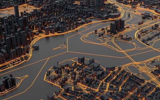
Geographical map drawings provide a clear visual and technical representation of land features, boundaries, elevations, access routes, and surrounding infrastructure. They allow planners, architects, engineers, and authorities to understand the physical characteristics of a site before any design or construction work begins. In rapidly developing regions such as the UAE, accurate mapping is essential to ensure compliance with zoning regulations, infrastructure alignment, and sustainable urban growth.
Role of Geographical Maps in Urban Planning
Urban planning relies heavily on spatial accuracy. Geographical map drawings help planners assess how land can be utilized efficiently while considering roads, utilities, public spaces, and environmental constraints. These maps support decision-making related to land subdivision, road connectivity, drainage planning, and public service placement.
Accurate geographical maps also help avoid conflicts between neighboring plots, reduce land disputes, and ensure that developments align with approved master plans. When planners have access to reliable mapping data, they can design cities that function efficiently and grow sustainably over time.
Supporting Regulatory Approvals and Compliance
One of the most critical uses of geographical map drawings is in regulatory approval processes. Municipal authorities, planning departments, and infrastructure agencies require precise maps to evaluate development proposals. These drawings must clearly show land boundaries, coordinates, access points, setbacks, and surrounding developments.
Inaccurate or incomplete geographical maps often result in application rejections, repeated revisions, and approval delays. Professionally prepared drawings ensure that submissions meet regulatory standards and reduce the risk of non-compliance. This not only saves time but also improves the credibility of the developer or consultant submitting the project.
Integration with Engineering and Infrastructure Design
Geographical map drawings play a vital role in engineering coordination. Infrastructure systems such as roads, drainage networks, water supply, and electrical services must be designed in alignment with actual site conditions. Accurate maps allow engineers to plan these systems efficiently while minimizing clashes and redesigns.
Elevation data, contour lines, and terrain analysis included in mapping drawings help engineers manage water flow, avoid flood risks, and design stable foundations. Without accurate geographical information, engineering designs are based on assumptions that can lead to structural or functional issues during construction.
Enhancing Cost Control and Risk Management
Errors in early-stage mapping often lead to major cost overruns later in the project lifecycle. Incorrect land measurements, missing site features, or outdated data can result in redesigns, construction delays, and material wastage. Accurate geographical map drawings reduce these risks by providing reliable data from the beginning.
When project teams work from precise maps, they can plan construction activities more efficiently, allocate resources correctly, and avoid unexpected site challenges. This improves overall cost control and reduces project uncertainty.
Supporting Sustainable and Smart City Development
Modern urban development increasingly focuses on sustainability and smart infrastructure. Geographical mapping supports environmental analysis, land-use optimization, and integration of green spaces. It allows planners to assess environmental impact, protect natural features, and design developments that respect ecological balance.
Accurate mapping is also essential for smart city initiatives that rely on digital data integration. Geographical maps serve as the base layer for GIS systems, smart infrastructure planning, and future urban expansion strategies.
Conclusion
Accurate geographical map drawings are not just technical documents; they are strategic tools that shape the success of urban development projects. From planning and approvals to engineering coordination and sustainability, these drawings influence every stage of development. Investing in professional geographical mapping ensures accuracy, compliance, efficiency, and long-term project success.
In modern urban environments, where precision and accountability are critical, high-quality geographical map drawings form the backbone of responsible and future-ready development.